
Snow and ice expected later this week across central and eastern U.S.
The coldest air is retreating from much of the eastern two-thirds of the country. However, enough cold air will linger around midweek to bring ice and snow to the upper Midwest and Northeast along with storms. A larger, more powerful storm is expected to bring colder air to parts of the region again later this week.
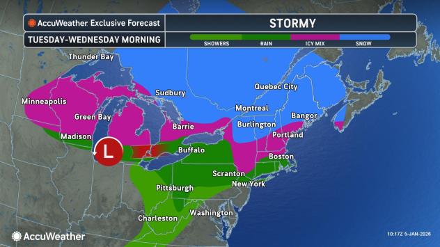
The northern region faces another round of snow and ice
As the storm moves eastward along the northern layer, the air near and south of Interstate 80 is expected to be too warm for snow or ice and generally too dry for widespread rainfall. A few showers with sleet and snow are likely along the higher terrain of Pennsylvania along Interstate 80.
Further north, some slippery conditions are expected, particularly on untreated roads and elevated surfaces.

AccuWeather.com
A mix of sleet, freezing rain and snow is expected from Minnesota to much of Wisconsin, northern and central Michigan, upstate New York and central New England.
Even slight icing can cause hazardous driving conditions, especially on untreated roads.

AccuWeather.com
Enough cold air is expected to support snowpack near the shores of Lake Huron eastward through southern Quebec, northeastern New York and northern New England.
Snowfall amounts of 1-6 inches are expected across the region, with AccuWeather Local StormMax™ snowfall amounts of up to 12 inches possible in parts of south-central Ontario, the Green and White Mountains of New England, and southeastern Quebec near the U.S. border.

AccuWeather.com
Much of the eastern two-thirds of the country is expected to emerge from the recent cold this week. Temperatures could challenge daily records Tuesday through Wednesday from Texas and the southern Plains into the Southeast, and along the South Atlantic coast on Thursday.
Western U.S. storms to impact dozens of states east of the Rockies later this week
A cross-country storm bringing rain and snow to the West on Tuesday is expected to move toward Texas on Thursday and then toward the Great Lakes region on Friday.

AccuWeather.com
As the storm moves along this path, it will carry moisture from the Pacific Ocean and then absorb additional moisture from the Gulf of Mexico. The phenomenon is expected to produce widespread precipitation — ranging from thunderstorms and heavy rain to ice and snow — across the central United States Thursday into Friday night.
Severe thunderstorms are possible in parts of the lower Mississippi River from Thursday into Friday.

AccuWeather.com
Additional gusty to severe thunderstorms are possible in parts of the Southeast over the weekend.
The exact location of the transition between rain, winter mix and snow in the Plains and Midwest will depend on the storm’s track.

AccuWeather.com
Farther east, expansion of warm air ahead of the storm will likely confine any winter mix primarily to northern Maine.
Get the free ACCUWeather app
As travel conditions improve from Tuesday to Wednesday in most central and eastern states, travel conditions are likely to worsen from Friday to Saturday, including at airports.

AccuWeather.com
Cold air will hit over the weekend
The storm is expected to end in the Northeast later this week, but may slow as another storm approaches and attempts to merge with it.
As colder air moves into the Great Lakes region Friday into Saturday, stronger winds could cause rain to turn to snow, with the potential for another round of lake-effect snow.
Want a higher level of security, ad-free? Unlock advanced, hyper-localized severe weather alerts when you subscribe to Premium+ on the AccuWeather app. AccuWeather Alerts™ are sent out by our professional meteorologists who monitor and analyze hazardous weather risks 24/7 to keep you and your family safer.