


Introduction
-
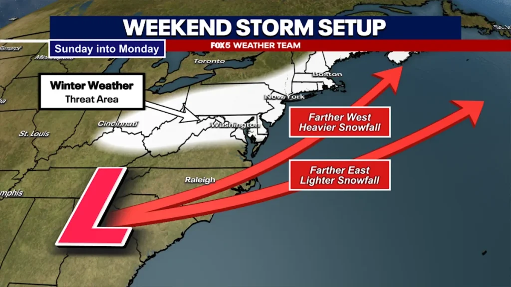
Weather models continue to debate the strength and location of the weekend storm system.
-
The most likely scenario is rain Sunday morning, then changing to rain or snow by Sunday night.
-
The threat of snow accumulation has emerged over the past 24 hours, with most models showing 1 to 5 inches of snowfall in the Washington area.
-
Some extreme solutions suggest that 6 inches or more is possible.
threaten
washington – Compared to previous weeks in the Washington area, this past week has been pretty good. Sure, it’s been pretty cloudy and cold, but temperatures have stayed above freezing, allowing the region to slowly but steadily shake off the so-called “snowpack” that has blanketed the Washington area for the better part of a month.
Temperatures are expected to stay above freezing next weekend, with the best day of the week likely to be Saturday, with some afternoon sunshine expected and temperatures in the mid-50s.
This pattern does start to change by Saturday night, though, as a strong drop in the jet stream causes temperatures to drop back into the 30s overnight Saturday into Sunday. Meanwhile, a storm system is expected to form ahead of this cold wave, which could bring widespread precipitation, including the threat of snow, to the Washington area.


snow debate
Of course, the big question is how much snow is there? Even with a potential storm system just days away, this question is still relatively difficult to answer.
The key to any potential storm system is its track and intensity. These are two questions weather models have been grappling with.
The general idea from our weather department tonight is closer to a European pattern. With temperatures starting well above freezing, this system will likely be rain-dominated Sunday morning.

Then, as the surface storm pushes eastward into the Atlantic, cold air fills in along a weather feature called an inverted surface trough as the storm moves away. This will bring the risk of the rain turning to mixed rain, with the possibility of a period of heavy wet snow on Sunday night.
Now, the tricky part about predicting an inverted trough situation is that the areas of snow tend to be in a relatively narrow band along the axis of the trough, so not everyone in the area is going to see a decent snowfall, it’s going to be concentrated within that band.
Predicting exactly where it will be set is difficult, and we won’t have a good idea of where the feature will be set until closer to Saturday night.
If this solution, which European models have been hinting at over the past few days, is the right solution, parts of our region could see 1-3 inches of snow, with the potential for 3-6 inches, as the storm moves from late Sunday night into early Monday morning.

On the other hand, U.S. model solutions now mostly suggest that the impact of the storm could be greater. As the jet stream slopes more strongly, weather models indicate that stronger storm systems will form and move closer to the coastline. Although rain also began to fall early Sunday morning, a strengthening surface low pressure quickly pulled cold air into the storm, causing temperatures to drop in the Washington area and turning the rainfall into widespread heavy snow.

The model is looking for a big, impactful snowfall for everyone, with final snowfall totals reaching double digits.
Now, most forecasters agree tonight that this solution is quite extreme and unlikely to happen with this storm. While we can’t rule out this possibility, it’s generally independent and most other guidance as of Thursday evening suggests lower snowfall totals are more likely.
So what is tonight’s debate if we don’t believe in America’s model solutions? The problem is the consistency of the model. Admittedly, weather models had a very poor forecast solution for Sunday’s storm system. Even European models, which historically do appear to be more accurate than U.S. models, are very “nervous” about this storm system. At times, the system will jump eastward, showing less snowfall, and then bring the storm back to the west, showing more snowfall. Forecasters look for consistency from run to run, but so far we haven’t seen that from any weather model.
The reason has a lot to do with the model. It’s not just one atmospheric energy that helps guide this storm system, but multiple energies. The more pieces involved in developing a storm system, the more likely it is that predictions will go wrong. That’s why we probably won’t get a really good handle on what this system is doing over the Washington area until closer to Friday night or even Saturday, when the portion of the energy involved in the formation of this storm system is well sampled and better analyzed.

What preparations are needed
This step will come down to calculating the amount of snowfall. What I can guarantee is that there will not be a repeat of the late January storm.
Even once the system kicks in, temperatures won’t be that cold – there will be no “snow” this time around. This could also be wet snow, and we may lose some snow as the ground melts in areas of the January system that are no longer covered in snow since temperatures have been above freezing most of the week.
One key thing we want to mention: A lot of people are saying, “But it’s too hot for snow on Sunday! The weather app says temperatures will be in the 40s!” While yes, it’s going to be too hot for snow to begin with… remember, your weather app is giving you the high temperatures for the day.
Through a process called dynamic cooling, when you introduce cooler air into the backside of a storm system, the temperature decreases due to the swing of the upper trough. As a result, temperatures will drop throughout the day.
The time frame we are most concerned about right now It’s Sunday afternoon, especially at night. While we currently don’t expect this to be a severe, city-closing type of snow, the most likely timing of the snow does mean there is a risk of closures and delays for schools and other activities Monday morning.
Of course, how wide these ranges really are will depend on the ultimate track and intensity of this storm system, and for the completeness of the forecast, we don’t yet have confidence that the snowfall amounts will match our expectations.
stay tuned
What we will continue to do is keep you updated and informed through Sunday.
Again, right now we are leaning towards a lower impact winter snowpack type event rather than a major snow storm.
FOX 5 will continue to monitor threats and let you know if we think a more influential system will hit the area.