A massive, widespread winter storm will hit much of the South, Midwest and Northeast from Friday, January 23 to Monday, January 26, with heavy snowfall likely for tens of millions of people from New Mexico to New England, Weather.com reports.
“It’s not an exaggeration to call this storm a monster,” Washington Post meteorologist Ben Knoll said on X on January 21. “At the peak of the storm on Sunday (January 25), 55% of people in the United States are expected to experience snow, sleet or freezing rain at the same time. That’s more than half of the population,” he said.
According to AccuWeather, widespread travel disruptions are possible across the country this weekend. “Snow-covered roads could force highway closures for several hours,” AccuWeather Chief Meteorologist Jonathan Porter said in an email to USA TODAY.
“East-west interstates critical to travel, commerce and deliveries, including Interstates 20, 30 and 40, may be closed at the same time, creating greater challenges for travelers and supply chains.”
In terms of total snowfall, AccuWeather said in an online forecast that heavy snow could reach 6 to 12 inches in the central Plains and more than 2 feet in parts of the Appalachian Mountains.
Snowfall amounts in the mid-Atlantic and Northeast will depend on the exact path of the storm, but significant amounts of plowable snow are possible – possibly a foot or more.
Southern Plains and South-Central
The heaviest snowfall is expected in central Oklahoma on Friday, January 23 and Saturday, January 24, possibly up to a foot, AccuWeather reports. Reduced rainfall amounts are possible in Arkansas, Kansas, Missouri, New Mexico and Texas, possibly 3-6 inches.
In Arkansas, the weather service said there is a 30-50 percent chance of more than 6 inches of snowfall in central and northern parts of the state. In Tennessee, areas north of Interstate 40 are most likely to see at least 6 inches of snow, the weather service said.
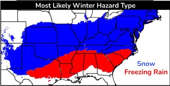
Weather.com meteorologist Jonathan Erdman said in an online forecast that snow, sleet and ice could sink southward in Texas, Louisiana and Mississippi, while snow, sleet and ice could sink in parts of Kentucky, Tennessee, West Virginia, Virginia and the Carolinas.

The coming storm is expected to bring widespread snow and freezing rain.
Southeast and East Coast
Winter precipitation in Texas, Oklahoma and the lower Mississippi River will end at noon on Sunday, January 25, but will continue from the Ohio Valley to the Virginia foothills and the Carolinas into the Northeast, Weather.com reports. Heavy snow is also possible in parts of the Ohio Valley.
According to Weather.com, the winter storm “has the potential to bring widespread heavy snow to the mid-Atlantic and Northeast this weekend.”
Maps posted by Weather.com showed snowfall totals of up to 2 to 3 feet in southern Virginia and 1 to 2 feet in large swaths of the mid-Atlantic.
Weather.com says: “The latest model trends show higher snowfall totals moving north toward Washington, Baltimore, and Philadelphia. The heaviest snowfall is expected Saturday night, January 24 through Sunday, January 25, making travel difficult or impossible. Snow could even persist in New England on Monday, January 26, depending on where the storm is located.”
Forecast uncertainty
According to the National Weather Service, “Confidence is high that a major storm will occur, but confidence is low on the specifics of the storm’s track, timing and precipitation amounts. Start preparing now for an impactful, long-lasting winter storm and stay up to date with the latest weather forecasts.”
Doyle Rice is a national correspondent for USA TODAY, covering weather and climate.
This article originally appeared on USA TODAY: How much snow will it get in your state this weekend? Check out the latest forecasts
